Lessons from Chornobyl: Wildfires Around Nuclear Infrastructure Can Aggravate Risks of Multiple Disasters
Wildfires around nuclear power plants can exponentially increase the combined disaster risks for local residents. Augurisk disaster risk assessment helps communities understand their risks and be better prepared.


In March 2022, the site of one of the world's most striking nuclear and ecological disasters was again on the front-page news. The Chornobyl nuclear power plant in Ukraine was captured by Russian military troops, who took its trained personnel hostages and disrupted the normal workflow of maintaining the plant's safety. As of Marсh 20, multiple wildfires approached the power plant, radioactive waste storage, and the Confinement. The latter is a giant structure that prevents the release of radioactive contaminants. The fire hazard was reported by the Ukrainian parliament and confirmed by the Fire Information for Resource Management System’s map.
According to Ukrainian officials, wildfires in the vicinity of the Chornobyl are considered dangerous if their total area exceeds 50 acres. As of March 20, the areas under fire were ten times larger than that. On March 27, the Ukrainian ombudsman reported about 10 thousand hectares of forests engulfed in flames. The situation was also exacerbated by the movement of numerous Russian military vehicles that raised the contaminated radioactive dust into the air.
In addition, the probability of further intensification of forest fires with the upcoming warmer spring weather and summer heat can elevate multiple disaster risks. This could lead to substantial deterioration of radiation levels in both Ukraine and all neighboring countries. The access for firefighters and international specialists to the territory of the unfolding disaster is considered impossible.
The Chornobyl power plant is notorious for the explosion and nuclear disaster in 1986, which led to significant radioactive contamination across Europe. Since then, the area of 2,600 km2 (1,000 mi2) around the plant has become an exclusion zone with restricted access for safety purposes.
What are the risks for the US?
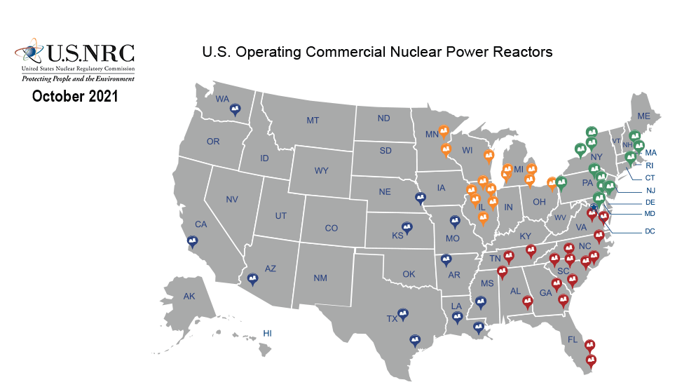
The U.S., located on the other side of the planet, is unlikely to be directly impacted by radioactive smoke from fires probably ignited by shelling in the first days of Russian invasion. Nevertheless, a similar risk exists on the territory of the United States, namely from the wildfires in proximity to numerous nuclear power units in operation. As of the end of 2020, there were 94 operating commercial nuclear reactors at 56 nuclear power plants in 28 states.
Currently, military actions are unlikely to ignite wildfires in the U.S. Yet, whatever sparks the flame, abnormal droughts will significantly contribute to the scale of wildfires. The dry winter season and below-normal precipitation have already significantly increased the probability of large blazes. Some experts claim climate change is the major factor for lengthened wildfire seasons, while the wet season gets shorter in the mainland United States.
As of March 2022, the number of fires and acres burnt across the US is nearly double the 10-year average, according to the National Interagency Fire Center. The inevitable wildfires in close vicinity of nuclear power plants increase the risk of multiple disasters similar to the one endured by Ukraine.
Wildfire and nuclear risks in the Pacific US
The Western U.S. is more prone to intense wildfires due to lack of moisture at the beginning of 2022. Scientists attribute the increasing abundance of dry flammable vegetation, longer span of fire season, and increased wildfire intensity in the south-western region to anthropogenic warming trends during the past century.
California and Arizona have five nuclear units in total. According to the National Interagency Fire Center, the wildfire potential in Arizona in spring will mostly increase in the eastern part of the state, comparatively far from nuclear generating stations. Yet, the potential for wildfires across much of coastal California is “above normal”. This is exactly where a power plant with 2 nuclear units is located.
As for the northwest, where there is another nuclear reactor, the official website of Seattle claims climate change only increases the likelihood of wildfires west of the Cascade Mountains, while the nuclear unit is located to the east of the mountain range. The National Interagency Fire Center does not mention the territory adjacent to the nuclear unit among those with significant wildfire potential, at least till June 2022.
Wildfire and nuclear risks in the South US
The multiple disaster risk for residents of the South U.S. is higher. The South has way more nuclear units than the western coast. In addition, fire activity across the region has increased this year. According to the National Interagency Fire Center, more than 90% of the acres burned in the U.S. were in the Southern Area.
Most of Texas remains in drought, according to the US Drought Monitor. Above normal, significant fire potential is expected for large portions of Texas through March and April. However, this is mainly western Texas, which is prone to fire risk, while the nuclear units are in the eastern part of the state.
Arkansas had above average precipitation in recent months, and along with Louisiana, Mississippi and Alabama, is not listed among the states at high risk of wildfires, according to the National Interagency Fire Center. Tennessee Valleys also had above average precipitation in February. All these states have nuclear units on their territory.
The total precipitation anomalies for February 2022 are shown on the image below.

Wildfire and nuclear risks in the Midwest US
The states over the Upper Mississippi Valley, where a dozen nuclear units of the Midwest are located, are expected to have an earlier than normal beginning of the spring fire season if precipitation does not increase over these areas.
Nebraska and Kansas previously had several wildfires during periods of warm, dry, and windy weather. The National Interagency Fire Center claims dry conditions are forecast to remain in most of these two states.
Ohio, as well as much of the Great Lakes region, on the contrary, are forecast to get generous precipitation through spring.
Wildfire and nuclear risks in the Atlantic US
Territories adjacent to nuclear units in the Northeast are at low risk of severe wildfires. It is forecast that the area will have above normal precipitation through spring.
The opposite situation is expected in most South Atlantic states. During March and April, higher than average fire potential is expected across Georgia and both Carolinas, and in Florida during the entire spring.
Wildfire and nuclear radiation risks assessment
Intensifying droughts resulting from climate change, and proximity to nuclear infrastructure, can create a combined multiple disaster threats. With global climate change, the climate patterns are altering, air temperatures are increasing, while precipitation patterns are changing. Despite its complexity, the multiple disasters risk can be assessed to a large extent with Augurisk disaster risk assessment in any location across the U.S.
To check if your property is at risk of wildfires and nuclear disasters in any location in the U.S., follow these steps:
- Login or sign up to the Augurisk disaster risk assessment platform.
- Press Add New Project
- Fill in your address
- Generate a Risk Audit
- Select Wildfires from the Environmental Risks menu
- Receive a detailed wildfire risk assessment of your location.
- Review the detailed map of the Wildfire Hazard potential for your location
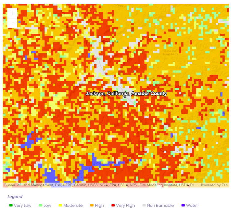
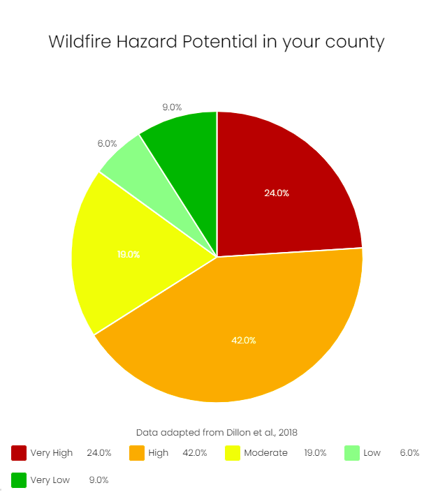
8. Look at the Wildfire Hazard Potential analysis in your county
9. Select Nuclear Radiation from the Societal Risks menu
10. Receive a detailed Nuclear Radiation risk assessment for your location.
11. Review the map of the US Nuclear Power Plants
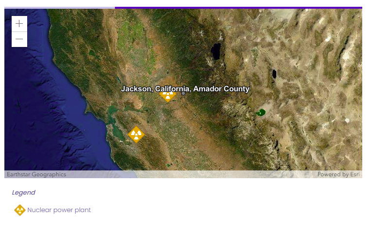
12. Consider the exact Distance to Power Plants from your location

13. Based on the gathered information, analyze the risks for your location in case of an incident related to wildfires and nuclear infrastructure.
Example of the Augurisk risk assessment summary report:
The wildfire hazard score at Jackson, California is very low. Note that in your area, an average 2.23 Fahrenheit degree increase in summer temperature is currently expected by the two Regional Climate Models (RCMs) selected by our team, which could affect wildfire hazard in the coming decades.
The Nuclear Hazard score at Jackson, California is 13.33 (very low). The nearest nuclear reactor is located 18 miles away.
As such, the U.S. EPA considers it an area where food and water contamination are possible and should be controlled in case of an incident.
If you have any questions about your wildfire and nuclear radiation risk assessments, contact us.